Topics Covered
- What is water level?
- What units are used to measure level?
- What affects water level?
- Why measure level?
- What methods are used to measure level?
- How do In-Situ sensors measure level?
- What are common challenges when monitoring level?
- What makes In-Situ pressure and level sensors unique?
- Which level sensor is right for your application?
- Additional Resources
What is water level?
Water level measures the height of a water body’s surface relative to a defined reference point. This reference may be a fixed structure, a geographical elevation or other relative point. Water level is used to quantify the depth or stage of water in natural or engineered systems and is critical for understanding hydrologic processes, managing water resources and ensuring performance and safety of water infrastructure systems.

What units are used to measure level?
Water level is typically expressed as a linear distance derived from a reference point. Standard units for reporting water level include millimeters (mm), centimeters (cm), meters (m), inches (in) and feet (ft), depending on the application and regional measurement conventions. Water level measurements can also be derived indirectly from pressure measurements. See “What methods are used to measure level?”

What affects water level?
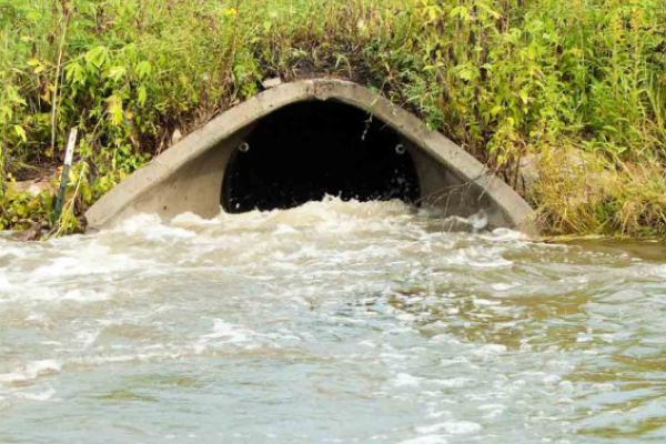
Surface Water & Coastal
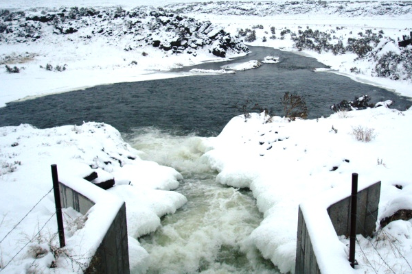
In surface water systems–such as rivers, lakes, wetlands and reservoirs–natural drivers of water level variability include precipitation, watershed runoff, evapotranspiration, upstream inflows, groundwater exchange, terrain slope and soil infiltration capacity. These processes determine how quickly and how much water enters or leaves a system. The rate of influx or drainage into these systems also influence water level fluctuations over time.
Human activities also significantly alter surface water level. Control infrastructure such as dams, weirs, levees, culverts and stormwater systems are designed to modify flow paths, control water storage and dictate when and how water is released or retained. Additionally, land use practices–such as urbanization, deforestation and agricultural activities–affect water level in a number of ways. These land use practices increase the frequency and intensity of level fluctuations via the water control systems mentioned above by increasing runoff volume and impact, or by reducing soil absorption capacity.
Water level in coastal ecosystems is influenced by a wide range of natural factors including tidal cycles, storm surges, wind, currents and atmospheric pressure variations. Long-term processes such as seasonal changes, sea level rise and geologic subsidence also play a role, as do climate phenomena like the El Niño-Southern Oscillation (ENSO), which can alter precipitation rates, ocean temperatures and other factors that alter water level over extended periods.
Human activity also influences coastal water level. Shoreline armoring, dredging, port infrastructure and land reclamation projects can all modify tidal flows and water retention in coastal areas. Coastal development often changes natural drainage patterns and decreases availability of permeable surfaces, which can increase and accelerate rates of runoff into estuarine and coastal nearshore environments. Additionally, global sea level rise on account of climate change contributes to long-term shifts in coastal water level and increases the frequency and severity of high-tide flood events.

Groundwater
Groundwater levels are influenced by a range of natural hydrologic and geologic factors. Precipitation–whether rainfall or snowmelt–is a primary driver of aquifer recharge, as water infiltrates the soil and percolates into aquifer systems. The timing, intensity and type of precipitation influence the effect of this process. For instance, shifts from snow to rain can accelerate runoff and reduce recharge, while prolonged droughts and dry seasons decrease soil’s ability to absorb precipitation, further exacerbating drops in groundwater level.
Soil type and underlying geology also play a critical role in this process. Sandy, porous soils promote infiltration and allow more water to seep down to aquifers due to their high hydraulic conductivity. Fine-grained or compact soils in clay-rich or rocky areas prevent infiltration. These soils’ low hydraulic conductivity limit water movement and reduce recharge potential.
Topography further influences groundwater distribution; water tends to accumulate in low-lying areas, where the water table may already sit closer to the surface. This decreases the distance precipitation has to travel to reach the aquifer, increasing recharge at these points.
Vegetation impacts water level as well. Plants–especially trees–draw moisture up from the ground through their roots, which can lower groundwater levels. But dense vegetation can also increase soil infiltration by reducing runoff, enhancing recharge in densely forested areas. Climate and seasonal fluctuations also regulate evapotranspiration rates. Warmer temperatures increase water loss from soils and vegetation, while colder temperatures decrease evapotranspiration and either cause groundwater levels to stabilize or increase. Climate change has altered precipitation patterns, snowmelt timing and aquifer recharge rates on an even larger scale, contributing to a profound and unprecedented shift in groundwater level and aquifer behavior.
Human activities significantly disrupt or alter natural groundwater dynamics. Groundwater extraction–for agricultural irrigation, municipal drinking water supplies or industrial use–can cause groundwater levels to sharply decline if pumping exceeds the rate of natural recharge. Urbanization also impacts the rate of aquifer recharge by increasing impermeable surfaces–like roads and buildings–that replace natural environments, reducing available surfaces where infiltration can occur and preventing aquifer recharge in those areas. Deforestation for industry or urban development further decreases the potential for recharge by reducing transpiration and altering soil structure.
Irrigation practices also affect groundwater levels. In regions with limited water supplies, large-scale irrigation can deplete aquifers, lowering groundwater levels long term. Over-irrigation may also lead to groundwater mounding, or a localized rise in the water table. Some regions work to counteract groundwater depletion through artificial recharge–intentional practices that facilitate aquifer replenishment. These methods include passive and active recharge of groundwater through infiltration basins or injection wells. These interventions can help stabilize groundwater levels, but require careful design and ongoing monitoring to ensure their sustainability and effectiveness.

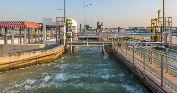
Water & Wastewater Treatment
Drinking water systems supplied by source water are dependent on all the same natural influences that affect surface water and groundwater levels. Rainfall, snowmelt, watershed runoff, evapotranspiration and seasonal patterns all govern the availability and fluctuation of source water. At the same time, human activities like upstream water withdrawals, reservoir operations, land use practices and climate-driven shifts in hydrology can impact the quantity and timing of source water availability.
Within drinking water facilities, natural variability in source water levels may play a role, but operational factors–like flow rate and system hydraulics–are much bigger influences on water level fluctuations throughout the treatment process. Inflow rate to the plant, efficiency and condition of filtration units, and the rate of treated water distribution all determine water levels across treatment stages and influence treatment effectiveness and approach to the process. For example, a decline in filter performance due to clogging or fouling may result in rising water levels before the filter, triggering maintenance or backwash cycles. Controls such as flow-balancing tanks, automated valves and real-time data help regulate process water levels to optimize treatment performance.
In wastewater treatment systems, the primary natural influence on water level fluctuations is precipitation. Heavy rainfall, snowmelt and high runoff events increase the volume of water entering sewer and collection networks, especially in areas with combined stormwater and sewer systems. These natural inflows can cause surges in influent volume at treatment facilities, leading to rapid changes in water level. During storm events, rapid increases in inflow from aging or compromised sewer lines can cause significant spikes in water level and may threaten to exceed treatment capacity.
But while storm events can dramatically alter influent volume, human activity is the most consistent influence on water level in wastewater systems. Residential, commercial and industrial water use patterns directly affect how much wastewater enters a collection system. Population growth, peak usage periods and infiltration from leaky infrastructure all create variable water levels that can affect the timing and magnitude of flow arriving at treatment plants. Upstream infrastructure such as pump stations, flow regulators and sewer design also play a role in flow–and therefore level–variability.

Why measure level?
Surface Water & Coastal
Water level measurements in surface water and coastal environments are essential for informed water resource management, risk assessment and infrastructure planning. In surface water systems, continuous monitoring provides both baseline data—capturing seasonal and long-term hydrologic trends—and event-driven data, which is critical during storms, floods or droughts. This information supports a wide range of applications, such as flood forecasting, real-time flood warning systems, drought preparedness, reservoir operations and ecological flow assessments. For example, tracking the rise and fall of water levels during storm events allows hydrologists and emergency managers to model the movement of flood crests through river networks and across floodplains, enabling timely, location-specific decisions.
In coastal environments, water level data underpins tidal analysis, storm surge monitoring and coastal mapping. It is used to predict high and low tide elevations, inform navigation safety, design resilient infrastructure and support habitat conservation in estuaries and wetlands. Long-term records also provide key indicators of sea level rise, subsidence and changing coastal dynamics, which are critical for coastal zone management, climate resiliency planning and regulatory compliance.
Across both systems, high-resolution water level data enhances hydrodynamic modeling, informs policy, and supports sustainability and land stewardship, while enabling more responsive and adaptive water management in the face of both short-term events and long-term change.

Groundwater
Groundwater level monitoring is fundamental to the sustainable management of water resources. Groundwater serves as a critical source of drinking water, agricultural irrigation and industrial use in many regions; monitoring level enables effective water supply management and helps ensure long-term water security.
Early detection of well overuse or depletion is critical to sustainable groundwater management, particularly in drought-prone areas or those that depend heavily on groundwater for agriculture. Severe drops in groundwater levels can indicate over-pumping, prompting the need for regulatory action or conservation measures before wells run dry or aquifers are irreversibly depleted.
Accurate groundwater level data also informs well design, operation and maintenance. Understanding the depth to the water table is essential for determining how deep a new well needs to be, evaluating whether existing wells remain usable, and deciding whether pumps need to be repositioned or replaced due to changes in drawdown or static water levels.
Over longer timeframes, level monitoring contributes to greater understanding of aquifer behavior. Continuous data can reveal the ongoing health or depletion of an aquifer by indicating whether a system is recharging seasonally or continuing to decline. This information is critical for developing sustainable groundwater management plans and hydrogeologic models.
Another key consideration is land subsidence, which can occur when excessive pumping causes the ground to compact and sink. Subsidence can create costly damage to private property and public infrastructure, and in severe cases can make entire areas uninhabitable. Continuous groundwater level monitoring can detect early warnings of subsidence and help prevent these outcomes.
Groundwater also plays a crucial role in supporting surface water systems. Stable groundwater levels help maintain baseline flow rates in rivers and springs, and ensure natural cycles continue in wetlands and riparian habitats. Sustainable groundwater management practices keep the water table steady and help maintain hydrologic connectivity between groundwater and surface water, thus allowing the natural processes of surface water ecosystems to continue.
Finally, groundwater data offers a valuable lens into climate change and the effects of drought. Because groundwater systems typically respond more slowly than surface water to changes in climate, monitoring groundwater level can offer unique insight into changing conditions and long-term trends in water behavior and availability. This makes groundwater level monitoring a key component of climate resiliency planning, drought preparedness and sustainable water use.

Water & Wastewater Treatment
In drinking water treatment, water level measurements serve several key functions, both within the plant and for source water monitoring. Within the plant, level can be used to assess filter performance and determine if filters need maintenance or replacement. If water level is higher on the influent side of the filter, it can indicate the filter is clogged or needs cleaning, prompting maintenance activities such as backwashing. Monitoring water levels at key locations ensures filtration systems remain effective so drinking water plants can produce the highest quality of finished water.
Level monitoring is also critical for source water management. For utilities drawing from reservoirs, lakes, rivers and groundwater, regular measurement of source water levels provides essential context for supply availability, seasonal variability and drought response planning. Similarly, storage tanks used in distribution systems rely on water level monitoring to manage inventory, maintain adequate pressure and optimize distribution cycles. These measurements support operational efficiency and emergency preparedness by ensuring sufficient reserves are available during high demand or service interruptions. And groundwater levels in water treatment are critical in coastal areas where saltwater intrusion is an issue.
In wastewater treatment facilities, water level monitoring plays a vital role in both process control and system capacity management. Within the plant, level measurements are commonly used in conjunction with flow measurement structures such as weirs and flumes to calculate accurate flow rates at various stages of treatment. Water level data also ensures that critical components like pumps and filtration systems operate within safe and effective ranges, preventing conditions like dry running or system surges that could damage equipment or disrupt treatment processes.
In collection systems, water level is an important metric for tracking hydraulic loading and flow variability across sewer networks. It provides insight into how much influent is being conveyed to the plant and how the system responds to excessive rainfall, usage patterns or other events that could increase typical loads. This information helps operators anticipate high-flow conditions, prevent backups or overflows, and maintain compliance with regulatory requirements related to stormwater management and combined sewer overflows (CSOs).
What methods are used to measure level?
Monitoring water level is essential for water resource management, flood forecasting, agricultural irrigation, environmental protection and many other applications. Methods to monitor water level have evolved significantly over time, from labor-intensive manual methods to automated systems with real-time data transmission. While modern water level monitoring favors automated systems for their low maintenance and efficiency, manual methods remain relevant for their simplicity, reliability and accessibility in parts of the world where infrastructure can’t support automated systems.
Contact Measurement Methods
Water Level Tapes
Water level tapes (or in some cases, chains) are among the oldest methods of monitoring water level and were commonly used for well management and early hydrological studies. The tape or chain is lowered into a well, reservoir or river–either to the water surface or to the bottom of the water body, depending on the location and preferred measurement method. Water level tapes are easy-to-use tools that provide accurate spot measurements with minimal equipment required. However, this manual method can become labor intensive (especially for remote sites) and varies with different users. While typically an older method, water level tapes are still used for field verification of automated measurements.

Staff Gauges
The staff gauge (or staff gage) is another early water level measurement method. It consists of a vertical board or metal plate marked with graduated measurements (typically in feet or meters) installed along a riverbank, reservoir or lake. This manual method requires someone onsite to verify and record the height water reaches on the gauge. Inexpensive and easy to install, staff gauges are a dependable and cost-effective reference for water level data. However, they require onsite presence to record a measurement, making them inefficient for continuous water level monitoring. Like water level tapes, their use today offers valuable visual confirmation of level readings provided by more efficient automated monitoring methods.

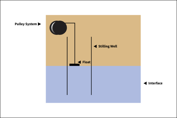
Float Systems
Though not commonly used today, float systems represent an important advancement in water level measurement. A float connected to a counterweight or pulley system is installed within a stilling well. The float rises and falls with the water surface, triggering a mechanism that records water level using a paper chart or rotating drum. This system represented a huge step forward by enabling automated level measurement and continuous data collection. The float system requires significant infrastructure and its use is limited by the availability of stilling wells. The mechanical parts are also vulnerable to fouling and wear, requiring frequent field visits for maintenance. With the development of digital sensors, float systems have largely been replaced by other methods of level measurement.
Bubbler Systems
Bubbler systems use a constant flow of air forced through a tube submerged in water. The pressure required to push air out of the tube is directly related to the height of the water column above it. This pressure is measured and converted into water level data. The system has no moving parts in the water, making it well-suited for locations with debris, sediment or ice. Compared to float systems, bubblers are more durable and require less maintenance in harsh conditions. However, they depend on an air compressor and are sensitive to leaks and blockages, which can affect reliability. They remain in use today in rugged environments where non-contact methods are impractical.

Pressure Transducers
Pressure transducers measure water level by sensing the hydrostatic pressure exerted by the water column above the sensor. They typically consist of a diaphragm that deflects in response to pressure changes. This deflection is converted into an electrical signal, which is then translated into a water depth measurement. Most pressure transducers are submersible, designed to be installed in the water column.
There are two main types of pressure transducers: non-vented and vented sensors. Non-vented pressure transducers measure absolute pressure (water + atmospheric pressure). Separate atmospheric pressure data (from a barometric pressure logger deployed alongside the transducer or from a nearby weather station) must be subtracted during post-processing to convert absolute readings into water level. Vented sensors measure gauge pressure (pressure relative to ambient atmospheric pressure). Vented sensors include a tube that runs from the sensor to the atmosphere, enabling automatic compensation of barometric pressure. This allows the sensor’s reading to reflect only the water column pressure, eliminating the need for post-correction of level data.
Compact and easy to install, the invention of pressure transducers marked a significant shift toward automated, continuous water data collection. Their small size and low power requirements make them ideal for high-frequency data collection in groundwater wells, small streams and remote sites. They can log readings internally as standalone instruments or pair with telemetry to improve efficiency and safety through remote monitoring and real-time alerts. Drift over time, vulnerability to fouling and temperature compensation are considerations during long deployments–as with any sensor. But overall, pressure transducers are widely used for reliable, low-maintenance access to continuous, high-frequency data.

Non-Contact Measurement Methods
Ultrasonic Sensors
Ultrasonic sensors emit a sound pulse toward the water surface and measure the time it takes the echo pulse to return. They use this time and the speed of sound to compute the distance or range to surface. Ultrasonic sensors are often mounted under bridges or above stilling basins. Compared to submerged measurement technologies, ultrasonic sensors offer the advantage of reduced fouling and maintenance, and protect instruments from damage due to debris and heavy flows. Ultrasonic sensors are more sensitive to atmospheric conditions since ambient air temperature and humidity impact the speed of sound. They’re also vulnerable to interference from environmental factors such as vegetation or debris that may block the signal from reaching the water’s surface, creating false readings. This makes careful site selection and installation critical to set these instruments up for success.

Radar Sensors
Radar sensors follow the same measurement principles as ultrasonic sensors, measuring the distance to a water body’s surface by emitting high-frequency electromagnetic radar pulses and calculating the time it takes for the signal to return. Radar sensors have gained popularity in recent years due to their high precision and durability in varying environmental conditions, including fog, dust and high humidity. Like other non-contact methods, radar sensors are easy to maintain and are free of the fouling that affects submerged equipment. They can be installed in hazardous sites without exposing instrumentation or personnel to difficult terrain or high flows, making them especially useful for flood forecasting and storm surge monitoring applications. While ultrasonic sensors may be impacted by foam, vegetation and other obstacles within the sensing cone, radar offers detection settings to overcome these challenges.

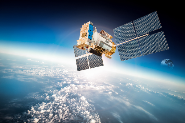
Altimetry
Altimetry involves measuring the distance from a fixed station–such as a drone, aircraft or satellite–to a water body’s surface. Altimetry can employ either laser or radar pulses to measure the elevation of the water surface based on the return time of the pulses to the monitoring station. Laser altimetry such as lidar (Light Detection and Ranging), are typically used for mapping large-scale surface water bodies and generating high-resolution topographic surveys. Lidar is especially valuable for large-scale hydrologic modeling, floodplain mapping and change detection over time. Satellite altimetry is more common in oceanographic applications as it is less accurate for small water bodies. While altimetry has expanded global access to data collection in regions with few on-the-ground monitoring networks, its limitations in temporal resolution make it a complement rather than a replacement for field-based level monitoring technologies. Laser and satellite monitoring are costly and not designed for high-frequency, real-time data collection.
How do In-Situ sensors measure level?
Pressure Transducers
Level sensors operate on the principle that water pressure increases with depth, and that pressure can be measured and translated into an electrical signal. Pressure sensors contain a diaphragm–a thin, flexible membrane typically made of stainless steel, titanium or ceramic. When the diaphragm is exposed to water pressure, the diaphragm deforms inward in proportion to increasing water level. The diaphragm’s diameter, thickness and stiffness determine how much it deflects under a given pressure. The limits of the diaphragm’s flexibility establishes the pressure range the sensor can accurately detect.
Directly behind the diaphragm is the sensing element–in In-Situ pressure sensors, a piezoresistive crystal. When a material is stretched or compressed, its electrical resistance changes in proportion to the strain. The sensing element is wired into a circuit that monitors this change in resistance. In other words, as the diaphragm flexes, it transfers mechanical strain to the crystal, causing a small but measurable change in the electrical resistance of the crystal. By applying a known current and measuring the resulting voltage (using Ohm’s law, V = I·R), the system can quantify the pressure applied to the diaphragm.
Behind the sensing element is the electronics board. This board includes the excitation circuitry for the piezoresistive crystal, an analog-to-digital converter, calibration data storage and onboard data logging for certain models. It interprets the raw electrical signal, applies factory calibrations and outputs a corresponding pressure value. This board is identical across sensor models, while the sensing tip and diaphragm vary depending on the required pressure range.
The entire sensor is enclosed in a fully-sealed waterproof housing, which provides rugged, corrosion-resistant protection from harsh environments. Fully-potted sensors cushion internal components against shock and vibration and protect electronics from water ingress. Their lack of moving parts makes submersible pressure sensors particularly resistant to mechanical failure. This low-maintenance profile, combined with a high degree of accuracy and stability, makes In-Situ pressure transducers ideal for long-term deployments in a diverse array of applications, particularly for continuous data collection in remote locations.

Radar Level Sensors
Radar level sensors like the Level TROLL NC determine the distance to the water surface by emitting high-frequency electromagnetic waves and measuring the time it takes for the reflected signal to return. The Level TROLL NC operates on this principle of time-of-flight using Frequency Modulated Continuous Wave (FMCW) radar signals. When the radar pulse reaches the surface of the material being monitored, part of the energy is reflected back toward the sensor. By precisely calculating the time delay between emission and reception and accounting for the speed of light, the sensor determines the distance to the material surface.
The sensor firmware then translates this distance into a level measurement or surface water elevation, based on the radar’s installation height and level reference. The non-contact nature of radar level measurement makes them ideal for use in harsh, corrosive environments where mechanical parts could degrade, become contaminated or get damaged during flood or storm surge conditions. And because radar waves are unaffected by temperature, pressure, vapor or dust, these sensors provide highly reliable readings even in challenging process conditions. Their robustness, accuracy and minimal maintenance requirements make radar level sensors a preferred choice in industrial, environmental and municipal water monitoring applications.

What are common challenges when monitoring level?
Monitoring water level comes with a host of challenges that can complicate location access, data collection and more. It’s important to understand and plan for these complications–and to carefully consider equipment maintenance and management–to protect data quality and ensure the longevity of monitoring installations.
Limited Access to Monitoring Locations
In many cases, it can be difficult to access groundwater wells or surface water monitoring stations. Monitoring sites may be located in remote, challenging conditions or on inaccessible land. Designated monitoring wells can be expensive to install and maintain; not every project will have access to wells expressly designed for groundwater monitoring.

Sparse Monitoring Networks
In many regions, there may not be enough wells to get a full picture of groundwater trends or not enough infrastructure to rapidly deploy stream gages for flood monitoring. Site selection restrictions like these can lead to data gaps and limit understanding of regional trends or aquifer behavior as a whole.

Time- and Labor-Intensive Methods
Collecting water level data manually–such as using a tape, electronic water level meter or a staff gage–requires trained personnel, consistently scheduled field visits and frequent travel to monitoring sites. Long-term monitoring programs that require manual data collection can quickly become tiring, resource-intensive and logistically challenging.

Seasonal and Short-Term Variability
Water levels naturally fluctuate due to rainfall, snowmelt, evapotranspiration and irrigation cycles. Similarly, surface and coastal water bodies experience isolated, short-term disturbances from wind, waves and boat traffic that can show up as fluctuations in level readings. These short-term variations can make it difficult to identify long-term trends. Continuous data collection and careful analysis are necessary to separate long-term trends from short-term cycles and the effects of individual events, like storm surges and flooding.
In cold climates, ice can interfere with data collection by affecting readings or making it impossible to access a site for maintenance, battery replacement or data collection. Ice can also block pressure ports or disrupt radar and ultrasonic signals.
Storm Surges and Flooding
Heavy flows and debris can damage equipment or dislodge installations, leading to data loss. Coastal storm surges may also cause saltwater intrusion, which adds corrosive stress to exposed equipment. To withstand these intense events, monitoring stations must be carefully selected and installed with rugged, durable equipment and housings.
Storm events also produce rapid, brief changes in water level. High-frequency logging is ideal for capturing peak water levels accurately. If dataloggers aren’t configured for high-resolution data collection–or if internal storage is limited–key information about the surge could be missed.
Human Impact and Development
Similarly, urbanization, infrastructure development, irrigation and other human activities can alter aquifer recharge and drawdown patterns. Urban areas present especially complex monitoring environments due to impervious surfaces and water diversion. Like seasonal variations, these influences can introduce unpredictable factors to groundwater data, making it more difficult to interpret.

Installation Constraints
Some wells are too narrow in diameter to accommodate pressure transducers. Depth and placement of a sensor within the well is also a constraint. If the sensor is too shallow, it may become exposed to air during drawdown events and create gaps in the data. But the deeper you install a sensor, the higher the pressure range you need. A higher pressure range can compromise the accuracy of the device, making it harder to collect accurate data.
Finding a representative site can be difficult in surface water and coastal applications as well. Monitoring locations need to remain stable, yet be close enough to flowing or open water to capture accurate level measurements. In dynamic environments, erosion, heavy flows and changing flow paths can affect sensor positioning and data accuracy. Similarly, vegetation or rocks in the path of a radar beam angle or ultrasonic device can contribute to site constraints. In these conditions, a narrow beam angle or other adaptation can provide more site selection flexibility.

Effects of Temperature on Readings
Water temperature affects the density of water and the performance of submersible pressure sensors. Although many transducers include temperature compensation, inaccuracies in compensation technology or extreme temperatures can still introduce errors in the data. In many cases, it can be difficult to access groundwater wells or surface water monitoring stations. Monitoring sites may be located in remote, challenging conditions or on inaccessible land. Designated monitoring wells can be expensive to install and maintain; not every project will have access to wells expressly designed for groundwater monitoring.

Barometric Pressure Corrections
Pressure transducers measure absolute pressure. Converting absolute pressure readings into water level data requires subtracting atmospheric pressure–either by using a vented sensor or pairing barometric loggers with your pressure transducer. Failure to correct for barometric pressure can result in misleading or erroneous data, especially during storms or rapid weather changes.
Fouling and Sediment Buildup
Sediment or buildup can clog or coat submerged sensors over time. Accumulations can affect readings and even damage sensors if left unattended. These conditions are common in wells with high turbidity or iron-rich groundwater. In surface water applications, debris such as leaves, branches or silt can obstruct sensors, especially in forested areas or those that experience storm events that move sediment and objects downstream. In coastal environments, sediment and debris displaced by dredging are more common causes of direct fouling. Non-contact sensors can experience fouling as well. Spider webs, branches and other debris can obstruct signal paths if they enter the active zone.

Power and Data Storage Limitations
Battery-powered loggers have finite power and internal data storage. Long-term deployments risk data loss if a battery dies or internal memory fills up before data is downloaded.
Physical Damage to Equipment
Sensor cables and vent tubes running to the surface in well installations are vulnerable to damage from wildlife, vandalism, flooding or lightning. For vented sensors, the vent tube must stay dry and intact; moisture intrusion into vent tubes or connectors can cause data loss or sensor failure.
Surface water and coastal installations in populated areas are at higher risk of vandalism and theft. Exposed sensors, cables or data loggers may be tampered with or removed, especially in recreational water bodies. Protective housings, secure enclosures and signage are often necessary to protect equipment from interference.

What makes In-Situ pressure and level sensors unique?
Enhanced Reliability
Our rugged titanium submersible pressure sensors are built to last. Sealed construction outperforms and outlasts specially coated dataloggers. Sealed battery and electronics reduce potential leak paths. And Kevlar-reinforced cables eliminate cable stretching that can appear as drift.
3D Factory Calibration
All sensors are calibrated across the full range of pressure and temperature to deliver accurate data across all field temperatures. Factory calibrations are NIST traceable and certified.

Easy to Deploy
All In-Situ level instruments are easy to install and deploy. Level TROLL submersible sensors require little setup and are designed with ruggedness in mind for low-maintenance, long-term deployments. The Level TROLL NC includes a bubble level for visual confirmation that the device is installed correctly. A versatile mounting bracket with integrated leveling bolts and multiple hole configurations support a variety of deployment scenarios.
Narrow Beam Angle
The Level TROLL NC’s 5° beam angle only requires a diameter clear zone of one meter at a range of 11.5 meters. A narrow beam increases installation flexibility, expanding site selection options to include deployments in tighter spaces.

Simplified Data Access
View data directly on your smartphone or tablet with the VuSitu mobile app. Consolidate site information, tag data with site photos and GPS coordinates, and watch parameters stabilize in real time during low-flow and pumping tests. And VuSitu automatically uploads all logs, low-flow reports and calibration reports to your HydroVu account for convenient, secure access to all your data in one central location.
Active Zone & Peak Detection
The VuSitu app displays the Level TROLL NC’s echo curve so you can assess signal return and surface reflection strength during installation. Customizable Active Zone settings allow you to fine-tune measurements. Change Peak Detection in VuSitu to enhance signal clarity and detection accuracy.

Shared Ecosystem
All In-Situ level instruments are compatible with the same cables, communication devices, telemetry, accessories and software for greater installation efficiency and flexibility. Equipment that all works together makes it easier to collect and access data and make the most of your time and resources.

Low-Maintenance Deployment
Powerful telemetry automates data collection. Ultra-low-power electronics and long-lasting batteries further reduce trips to the field. Hydrophobic filters and replaceable desiccants extend deployment and instrument life.
Simplified Data Management
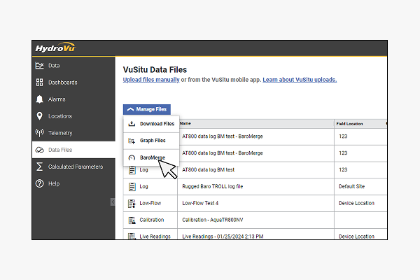
Access data in real time through HydroVu. Set customizable multi-condition alarms for real-time alerts to changing conditions. Apply automatic post-corrections to absolute water level data with BaroMerge. View historical trends or drill down into details like timeframe, location, parameter or another label of your choice. And use HydroVu’s simple API to get your data where it needs to go.
Which level sensor is right for your application?
 Level TROLL NC£1,190.00Pricing only valid in the U.K.
The Level TROLL NC is a high-performance, non-contact radar sensor designed for precise water level measurement in challenging environments.
 Rugged TROLL 100 Data Logger£350.00Pricing only valid in the U.K.
In-Situ’s most economical option for measuring and logging water level, water pressure and temperature. Use this durable, non-vented (absolute) water level logger in long-term baseline monitoring, and periodically download data with the Rugged TROLL Docking Station or Wireless Rugged TROLL Com and VuSitu App.
 BaroTROLL Data Logger£750.00Pricing only valid in the U.K.
Use the BaroTROLL Data Logger with non-vented (absolute) In-Situ instruments to conveniently measure and log barometric pressure and temperature—data used to compensate for water level changes due to barometric fluctuations.
 Rugged BaroTROLL Data Logger£350.00Pricing only valid in the U.K.
Measures and logs barometric pressure and temperature to compensate for water level changes due to barometric fluctuations.
 Rugged TROLL 200 Data Logger£510.00Pricing only valid in the U.K.
Measures and logs water level, water pressure and temperature. This economical, non-vented (absolute) water level logger is ideal for long-term baseline monitoring.
 Level TROLL 500 Data Logger£1,100.00Pricing only valid in the U.K.
A cost-effective, sub 1-inch, vented option suited for a variety of fresh, saline and contaminated water applications.
 Level TROLL 700 Data Logger£1,335.00Pricing only valid in the U.K.
In-Situ’s premier water level logger, ideal for groundwater professionals who require higher data resolution, expanded memory and advanced logging modes for specialized applications.
 Water Level Meter 100£570.00Pricing only valid in the U.K.
Economical water level meter, with lengths available in feet or meters.
 Water Level Meter 200£615.00Pricing only valid in the U.K.
Engineer-grade water level meter, with lengths available in feet and meters.
 Aqua TROLL 100 Data Logger£1,500.00Pricing only valid in the U.K.
Measures and records conductivity and temperature.
 Aqua TROLL 200 Data Logger£1,665.00Pricing only valid in the U.K.
Measures and records water level and pressure, conductivity and temperature. Vented or non-vented.
 EchoFlo Ultrasonic Depth Sensor£605.00Pricing only valid in the U.K.
The MACE EchoFlo features patented Digital Signal Processor (DSP) technology that allows level measurement in a limited space. With a minimal 2″ (50mm) dead band and narrow beam-width, the EchoFlo can be deployed in a diverse range of applications.
Additional Resources
- Webinar Are You Flood Ready?
Cost-Effective Monitoring Solutions for Data-Driven Emergency Management - Webinar What You Need To Know About Water Level Measurement With A Pressure Sensor
- Webinar How to Get the Most of Your Transducer Data
- Webinar How to Make Low-Flow Groundwater Purging Easy, Affordable and Reliable
- News How Much to Purge?
- News BaroMerge Is Now Available in HydroVu
- News Your Go-To Guide for Efficient Aquifer Testing
- News A Well-Established Industry: The Evolution of Groundwater Monitoring
- News Water Level Measurements with a Pressure Transducer
- News TECH NOTE: Absolute (Non-Vented) and Gauge (Vented) Pressure Sensors